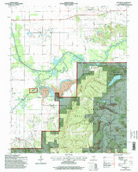
1996 Map of Rudement
USGS Topo · Published 1998About this map
Shawnee Mountain and the extensive Shawnee National Forest dominate the southern portion of this landscape, where deep hollows like Hargrave Hollow and Blue Spring Hollow carve through the timbered terrain. The transition from the rugged hills of the south to the northern agricultural and mining plains is marked by the meandering River Saline and its complex system of wetlands, including Davis Slough and Setter Slough. Evidence of the region’s long-standing coal industry is visible in the scattered Strip Mines and the Vinyard Mine near the settlement of Cottage Grove.
Find a feature on this map
59 named features on this map. Tap any name to fly to it.
Don’t see what you’re looking for? This feature index may not catch every label — zoom into the map to look around manually.
Map Details
Editions of this 1996 Rudement Map
This is the sole edition of this map. No revisions or reprints were ever made.
Other maps of this area

1905 · Eldorado
USGS Topo · 1:62,500

1906 · Eldorado
USGS Topo · 1:62,500

1908 · Galatia
USGS Topo · 1:62,500

1916 · Equality
USGS Topo · 1:62,500

1925 · Harrisburg
USGS Topo · 1:62,500

1938 · Galatia
USGS Topo · 1:62,500

1939 · Harrisburg
USGS Topo · 1:62,500

1949 · Paducah
USGS Topo · 1:250,000

1950 · Paducah
USGS Topo · 1:250,000

1954 · Paducah
USGS Topo · 1:250,000