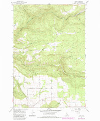
1967 Map of Rudo
USGS Topo · Published 1985About this map
The Nez Perce Indian Reservation Boundary cuts diagonally through this Clearwater County landscape, marking a significant division between reservation land and the surrounding territory. The drainage of Orofino Creek and its many tributaries, including Camas Creek and Prairie Creek, dominates the northern half of the map with steep, wooded slopes. To the south, the terrain transitions into a more settled agricultural pattern centered around the community features of Fraser Grange, Fraser Park, and the Fraser Cem. Small settlements like Rudo and Cooper are located along the creek valleys and upland ridges, connected by a network of light-duty and unimproved roads. The presence of a Gravel Pit near Cook Creek suggests local resource extraction alongside the established farming and ranching communities of the mid-20th century.
Find a feature on this map
16 named features on this map. Tap any name to fly to it.
Don’t see what you’re looking for? This feature index may not catch every label — zoom into the map to look around manually.
Map Details
Editions of this 1967 Rudo Map
3 editions found

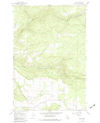
Other maps of this area

1923 · Washington Creek
USGS Topo · 1:125,000

1924 · Kamiah
USGS Topo · 1:125,000

1924 · Weippe
USGS Topo · 1:125,000

1938 · Headquarters
USGS Topo · 1:48,000

1944 · Headquarters
USGS Topo · 1:62,500

1955 · Pullman
USGS Topo · 1:250,000

1956 · Hamilton
USGS Topo · 1:250,000

1958 · Pullman
USGS Topo · 1:250,000

1959 · Hamilton
USGS Topo · 1:250,000

1960 · Hamilton
USGS Topo · 1:250,000