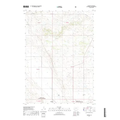
2017 Map of Rumford
USGS Topo · Published 2017About this map
Rumford sits at a junction of rural routes in the southwestern corner of this survey, surrounded by the wide open spaces of the Buffalo Gap National Grassland. The landscape is defined by the broad expanses of Plains Valley and Hat Creek Flat, where seasonal watercourses like Horse Cr and Piney Cr carve subtle paths across the prairie. The map details a transition from the lower alluvial flats toward the rising draws and drainages of Indian Canyon Rd and Tall Grass RD in the north.
Find a feature on this map
19 named features on this map. Tap any name to fly to it.
Don’t see what you’re looking for? This feature index may not catch every label — zoom into the map to look around manually.
Map Details
Editions of this 2017 Rumford Map
This is the sole edition of this map. No revisions or reprints were ever made.
Other maps of this area

1902 · Edgemont
USGS Topo · 1:125,000

1950 · Edgemont
USGS Topo · 1:24,000

1950 · Heppner
USGS Topo · 1:24,000

1950 · Cascade Springs
USGS Topo · 1:24,000

1950 · Rumford
USGS Topo · 1:24,000

1950 · Flint Hill
USGS Topo · 1:24,000

1955 · Hot Springs
USGS Topo · 1:250,000
1982 · Crowe Dam
USGS Topo · 1:25,000
1982 · Provo
USGS Topo · 1:25,000
1982 · Ardmore
USGS Topo · 1:25,000