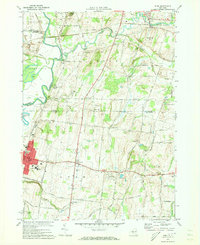
1971 Map of Rush
USGS Topo · Published 1973About this map
The Genesee River and Honeoye Creek define the western and northern corridors of this landscape, carving through a region marked by extensive gravel operations and a shifting rail infrastructure. In the early 1970s, the remnants of the Lehigh Valley and Erie-Lackawanna railroads still crisscross the terrain, connecting small hubs like Golah and West Rush. The map captures the interface between industrial extraction and residential growth, seen in the proximity of numerous Gravel Pits to established settlements like East Avon and Meadow Wood.
Find a feature on this map
54 named features on this map. Tap any name to fly to it.
Don’t see what you’re looking for? This feature index may not catch every label — zoom into the map to look around manually.
Map Details
Editions of this 1971 Rush Map
Other maps of this area

1895 · Rochester
USGS Topo · 1:62,500

1898 · Rochester
USGS Topo · 1:62,500

1899 · Brockport
USGS Topo · 1:62,500

1901 · Honeoye
USGS Topo · 1:62,500

1904 · Caledonia
USGS Topo · 1:62,500

1904 · Honeoye
USGS Topo · 1:62,500

1912 · Rochester
USGS Topo · 1:62,500

1920 · Rochester
USGS Topo · 1:62,500

1931 · Mendon Ponds
USGS Topo · 1:24,000

1934 · Rush
USGS Topo · 1:24,000