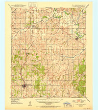
1950 Map of Rush Springs
USGS Topo · Published 1950About this map
The Indian Territory Boundary Line remains a prominent fixture on this mid-century landscape of Grady County, cutting north-south across the western sections of the map. This survey reveals a post-war rural infrastructure dominated by the Chicago Rock Island and Pacific railroad, which links the towns of Ninnekah, Alex, and Rush Springs. To the south, the development of the Rush Springs Oil Field is evidenced by numerous Gas Wells and Oil Well symbols dotting the terrain. The map is particularly rich for genealogical research, documenting a dense network of country schools and rural churches that served these farming and drilling communities. Notable educational sites include Vimy Ridge Sch, Elm Flat Sch, and Pea Ridge Sch, while local history is preserved at locations such as Sandy Grove Cem and Baptist Ch. The winding course of the Washita River and its many tributaries, including Roaring Creek and Rush Creek, provide the primary drainage for this active agricultural and industrial region.
Find a feature on this map
49 named features on this map. Tap any name to fly to it.
Don’t see what you’re looking for? This feature index may not catch every label — zoom into the map to look around manually.
Map Details
Editions of this 1950 Rush Springs Map
2 editions found
Other maps of this area

1902 · Rush Springs
USGS Topo · 1:125,000

1904 · Chickasha
USGS Topo · 1:125,000

1945 · Anadarko
USGS Topo · 1:62,500

1949 · Cement
USGS Topo · 1:62,500

1949 · Nellie
USGS Topo · 1:62,500

1949 · Rush Springs
USGS Topo · 1:62,500

1950 · Rush Springs
USGS Topo · 1:62,500

1950 · Marlow
USGS Topo · 1:62,500

1951 · Marlow
USGS Topo · 1:62,500

1954 · Oklahoma City
USGS Topo · 1:250,000