
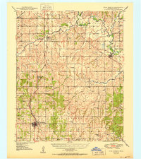
1950 Map of Rush Springs
USGS Topo · Published 1950About this map
The Washita River and its meandering tributaries, including the Little Washita River and Winter Creek, define this mid-century portrait of Grady County. Established agricultural and transport patterns are evident along the Chicago Rock Island and Pacific railroad, which links the primary settlements of Ninnekah, Alex, and Rush Springs. The landscape is dotted with evidence of early 20th-century rural infrastructure, from numerous country schools like Sperling Sch and Sandy Grove Sch to the scattered Gas Wells and Oil Wells that indicate the era's growing petroleum industry.
Find a feature on this map
50 named features on this map. Tap any name to fly to it.
Don’t see what you’re looking for? This feature index may not catch every label — zoom into the map to look around manually.
Map Details
Editions of this 1950 Rush Springs Map
2 editions found
Other maps of this area

1902 · Rush Springs
USGS Topo · 1:125,000

1904 · Chickasha
USGS Topo · 1:125,000

1945 · Anadarko
USGS Topo · 1:62,500

1949 · Cement
USGS Topo · 1:62,500

1949 · Nellie
USGS Topo · 1:62,500

1949 · Rush Springs
USGS Topo · 1:62,500

1950 · Marlow
USGS Topo · 1:62,500

1951 · Marlow
USGS Topo · 1:62,500

1954 · Oklahoma City
USGS Topo · 1:250,000

1955 · Lawton
USGS Topo · 1:250,000