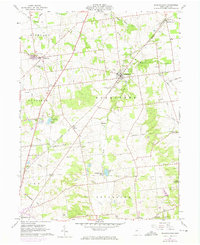
1961 Map of Rushsylvania
USGS Topo · Published 1974About this map
The Greenville Treaty Line cuts a historical diagonal across this landscape, marking a former frontier boundary that still influences the cadastral patterns of Logan County. Settlement centers around the village of Rushsylvania, where the Penn Central railroad serves as a primary transit corridor through the fertile headwaters of the South Fork Great Miami River and Rush Creek. The map documents a deeply rooted rural community, evidenced by numerous small family and local burial grounds like McKirahan Cem, Fulton Cem, and Stanfield Cem. Small hamlets such as Big Springs, Marl City, and New Jerusalem are interspersed with agricultural features and specialized sites including the Kilns near Marl City and the Bellefontaine Airport. The southern reaches transition toward the Mad River valley, including recreational landmarks like Zane Caverns Park.
Find a feature on this map
42 named features on this map. Tap any name to fly to it.
Don’t see what you’re looking for? This feature index may not catch every label — zoom into the map to look around manually.
Map Details
Editions of this 1961 Rushsylvania Map
Other maps of this area

1913 · Alger
USGS Topo · 1:48,000

1913 · Bellefontaine
USGS Topo · 1:48,000

1913 · East Liberty
USGS Topo · 1:62,500

1915 · Alger
USGS Topo · 1:62,500

1915 · Bellefontaine
USGS Topo · 1:62,500

1915 · East Liberty
USGS Topo · 1:62,500

1915 · Kenton
USGS Topo · 1:62,500

1943 · Alger
USGS Topo · 1:62,500

1944 · East Liberty
USGS Topo · 1:62,500

1944 · Kenton
USGS Topo · 1:62,500