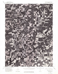
1975 Map of Rushville NE
USGS Topo · Published 1976About this map
Littleton anchors the northwest corner of this agricultural landscape in Schuyler County, where a dense grid of farmland and timber tracts is captured in high-detail orthophoto imagery. The terrain is defined by the winding course of Sugar Creek and its many wooded tributaries, which break the geometric patterns of the surrounding fields. At the southern edge of the sheet, the northern fringes of Rushville emerge, showing the transition from rural acreage to the town's expanding residential and commercial footprint. This orthophotoquad serves as a precise record of land use and vegetation patterns in the mid-1970s, illustrating the relationship between the natural drainage of the creek systems and the systematic development of the Illinois prairie.
Find a feature on this map
3 named features on this map. Tap any name to fly to it.
Don’t see what you’re looking for? This feature index may not catch every label — zoom into the map to look around manually.
Map Details
Editions of this 1975 Rushville NE Map
This is the sole edition of this map. No revisions or reprints were ever made.
Other maps of this area

1912 · Macomb
USGS Topo · 1:62,500

1914 · Macomb
USGS Topo · 1:62,500

1918 · Vermont
USGS Topo · 1:62,500

1921 · Vermont
USGS Topo · 1:62,500

1923 · Rushville
USGS Topo · 1:62,500

1926 · Beardstown
USGS Topo · 1:62,500

1926 · Rushville
USGS Topo · 1:62,500

1944 · Beardstown
USGS Topo · 1:62,500

1947 · Vermont
USGS Topo · 1:24,000
1948 · Vermont
USGS Topo · 1:24,000