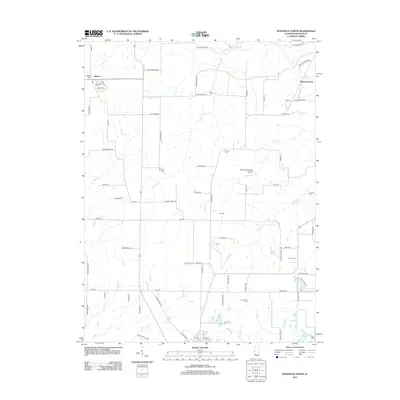
2012 Map of Rushville North
USGS Topo · Published 2012About this map
Littleton and the crossroads of Oakland Center anchor this rural landscape in Schuyler County, where a dense network of country roads connects family lands and community landmarks. The terrain is defined by the branching tributaries of the Illinois River watershed, including the winding paths of McKee Br, Sugar Cr, and Stony Cr. For those tracing local heritage, the map identifies numerous small burial grounds dispersed throughout the township, such as Moore Cem, Gillenwater Cem, and Bethany Cem. Transportation and infrastructure are represented by the Randolph M Wells Airport and the persistent grid of rural routes like Log Cabin Rd and Moore Chapel Rd, reflecting the enduring agricultural character of the region. The map preserves the specific placement of these rural features as they existed in the early 21st century.
Find a feature on this map
79 named features on this map. Tap any name to fly to it.
Don’t see what you’re looking for? This feature index may not catch every label — zoom into the map to look around manually.
Map Details
Editions of this 2012 Rushville North Map
This is the sole edition of this map. No revisions or reprints were ever made.
Other maps of this area

1912 · Macomb
USGS Topo · 1:62,500

1914 · Macomb
USGS Topo · 1:62,500

1918 · Vermont
USGS Topo · 1:62,500

1921 · Vermont
USGS Topo · 1:62,500

1923 · Rushville
USGS Topo · 1:62,500

1926 · Beardstown
USGS Topo · 1:62,500

1926 · Rushville
USGS Topo · 1:62,500

1944 · Beardstown
USGS Topo · 1:62,500

1947 · Vermont
USGS Topo · 1:24,000
1948 · Vermont
USGS Topo · 1:24,000