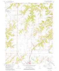
1981 Map of Rushville North
USGS Topo · Published 1981About this map
The northern reaches of Rushville and the rural village of Littleton anchor this portrait of Schuyler County, Illinois, during the late 1970s and early 1980s. The landscape transitions from the gridded agricultural fields of Buena Vista and Littleton townships to the intricate drainage basins of Sugar Creek and Crane Creek. This era of the landscape is defined by the heavy footprint of the Burlington Northern railroad, which cuts through the dissected terrain near Rich Branch and Sloan Creek.
Find a feature on this map
40 named features on this map. Tap any name to fly to it.
Don’t see what you’re looking for? This feature index may not catch every label — zoom into the map to look around manually.
Map Details
Editions of this 1981 Rushville North Map
This is the sole edition of this map. No revisions or reprints were ever made.
Other maps of this area

1912 · Macomb
USGS Topo · 1:62,500

1914 · Macomb
USGS Topo · 1:62,500

1918 · Vermont
USGS Topo · 1:62,500

1921 · Vermont
USGS Topo · 1:62,500

1923 · Rushville
USGS Topo · 1:62,500

1926 · Beardstown
USGS Topo · 1:62,500

1926 · Rushville
USGS Topo · 1:62,500

1944 · Beardstown
USGS Topo · 1:62,500

1947 · Vermont
USGS Topo · 1:24,000
1948 · Vermont
USGS Topo · 1:24,000