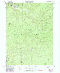
1966 Map of Russell City
USGS Topo · Published 1991About this map
Russell City and the surrounding wilderness of the Allegheny National Forest define this 1966 topographic survey of the Pennsylvania highlands. The landscape is a complex network of narrow hollows and high ridges, heavily marked by the extraction industry with an extensive Oil and Gas Field spanning the central and eastern portions. This industrial footprint is visible through numerous gas wells and pipelines that crisscross the terrain, often located in areas far from formal roads.
Find a feature on this map
57 named features on this map. Tap any name to fly to it.
Don’t see what you’re looking for? This feature index may not catch every label — zoom into the map to look around manually.
Map Details
Editions of this 1966 Russell City Map
4 editions found
Other maps of this area

1918 · Loleta
USGS Topo · 1:62,500

1934 · Kane
USGS Topo · 1:48,000

1935 · Sheffield
USGS Topo · 1:48,000

1936 · Marienville
USGS Topo · 1:48,000

1939 · Kane
USGS Topo · 1:62,500

1940 · Hallton
USGS Topo · 1:48,000

1941 · Sheffield
USGS Topo · 1:62,500

1941 · Marienville
USGS Topo · 1:62,500

1943 · Hallton
USGS Topo · 1:62,500

1957 · Warren
USGS Topo · 1:250,000
Featured Places
- Sheffield Township, PA
- Dunring, Jenks Township
- Brookston, Howe Township
- Sheffield Junction, Howe Township
- Wetmore Township, PA