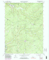
1966 Map of Russell City
USGS Topo · Published 1991About this map
The extractive industries of the mid-twentieth century dominate this landscape in the Allegheny National Forest, where a dense network of gas wells and oil fields spreads across the high plateaus. Small settlements like Russell City and Chaffee serve as focal points along the Baltimore and Ohio Railroad, which cuts through the rugged creek valleys of the Tionesta Creek watershed. The map reveals the infrastructure of a working forest, including a Pumping Sta near Sackett and various jeep trails and old grades that connect isolated outposts such as Duhring and Pine Camp. This survey documents a transition in the region's economy, where historic rail junctions like Sheffield Junction coexist with expanding energy production fields like the Oil and Gas Field surrounding Four Corners.
Find a feature on this map
55 named features on this map. Tap any name to fly to it.
Don’t see what you’re looking for? This feature index may not catch every label — zoom into the map to look around manually.
Map Details
Editions of this 1966 Russell City Map
4 editions found
Other maps of this area

1918 · Loleta
USGS Topo · 1:62,500

1934 · Kane
USGS Topo · 1:48,000

1935 · Sheffield
USGS Topo · 1:48,000

1936 · Marienville
USGS Topo · 1:48,000

1939 · Kane
USGS Topo · 1:62,500

1940 · Hallton
USGS Topo · 1:48,000

1941 · Sheffield
USGS Topo · 1:62,500

1941 · Marienville
USGS Topo · 1:62,500

1943 · Hallton
USGS Topo · 1:62,500

1957 · Warren
USGS Topo · 1:250,000
Featured Places
- Sheffield Township, PA
- Dunring, Jenks Township
- Brookston, Howe Township
- Sheffield Junction, Howe Township
- Wetmore Township, PA