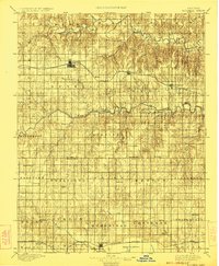
1896 Map of Russell
USGS Topo · Published 1924About this map
Russell and the surrounding high plains of Central Kansas appear here just as the nineteenth century drew to a close. The landscape is defined by the parallel courses of the Saline River and Smoky Hill River, with the Union Pacific rail line connecting primary shipping points like Bunker Hill and Dorrance. To the south, the topography shifts into the wetlands of Cheyenne Bottoms near the growing hub of Hoisington, where the Missouri Pacific R. R. establishes a second vital transport corridor. The map preserves the locations of numerous small community centers and post offices that served homesteaders in townships like Wheatland and Beaver, including Dubuque, Odin, and Galatia, providing a clear view of the rural network before the consolidation of agricultural settlements.
Find a feature on this map
54 named features on this map. Tap any name to fly to it.
Don’t see what you’re looking for? This feature index may not catch every label — zoom into the map to look around manually.
Map Details
Editions of this 1896 Russell Map
4 editions found
Other maps of this area

1889 · Larned
USGS Topo · 1:125,000

1891 · Great Bend
USGS Topo · 1:125,000

1891 · Larned
USGS Topo · 1:125,000

1893 · Great Bend
USGS Topo · 1:125,000

1894 · Ellsworth
USGS Topo · 1:125,000

1894 · Lyons
USGS Topo · 1:125,000

1894 · Beloit
USGS Topo · 1:125,000

1896 · Osborne
USGS Topo · 1:125,000

1896 · Russell
USGS Topo · 1:125,000

1896 · Hays
USGS Topo · 1:125,000