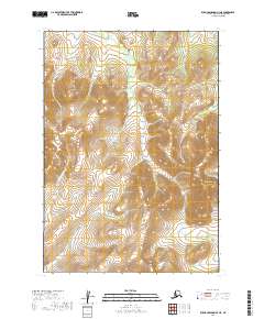
2019 Map of Russian Mission A-3 NE
USGS Topo · Published 2019About this map
Mt Hamilton dominates the eastern edge of this 2019 survey, providing a topographical anchor for a landscape defined by its network of high-elevation drainages. The Tuluksak River flows through the southwestern corner, while Ophir Cr, Hot Spring Cr, and Bear Cr carve through the high country. A significant geographic passage is noted at Rockpile Pass, situated between the headwaters of several drainages near the boundary of t13n r58w and t13n r59w. The land divisions across these townships indicate a wilderness area largely untouched by permanent settlements or improved roadways, instead marked by the natural paths of alpine creeks and mountain passes. This map serves as a precise record of the regional hydrography and terrain as it stood in the early 21st century.
Find a feature on this map
10 named features on this map. Tap any name to fly to it.
Don’t see what you’re looking for? This feature index may not catch every label — zoom into the map to look around manually.
Map Details
Editions of this 2019 Russian Mission A-3 NE Map
This is the sole edition of this map. No revisions or reprints were ever made.
Other maps of this area

1947 · Russian Mission
USGS Topo · 1:250,000

1950 · Russian Mission
USGS Topo · 1:250,000

1952 · Russian Mission B-2
USGS Topo · 1:63,360

1952 · Russian Mission B-3
USGS Topo · 1:63,360

1954 · Russian Mission A-3
USGS Topo · 1:63,360

1979 · Russian Mission A-2
USGS Topo · 1:63,360

1980 · Russian Mission
USGS Topo · 1:250,000
2019 · Russian Mission A-3 NW
USGS Topo · 1:25,000
2019 · Russian Mission B-3 SW
USGS Topo · 1:25,000
2019 · Russian Mission A-2 NW
USGS Topo · 1:25,000