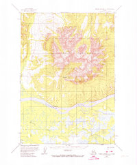
1952 Map of Russian Mission C-1
USGS Topo · Published 1974About this map
Russian Mountains dominate the interior of this 1950s landscape, their high peaks rising sharply above the winding Kuskokwim River. This survey captures the region just before mid-century revisions, documenting the small settlement of Chuathbaluk along the northern riverbank. The terrain is defined by a network of drainage systems, including Mission Creek and Doestock Creek, which carve through the lowlands and foothills.
Find a feature on this map
13 named features on this map. Tap any name to fly to it.
Don’t see what you’re looking for? This feature index may not catch every label — zoom into the map to look around manually.
Map Details
Editions of this 1952 Russian Mission C-1 Map
2 editions found
Other maps of this area

1947 · Russian Mission
USGS Topo · 1:250,000

1950 · Russian Mission
USGS Topo · 1:250,000

1950 · Sleetmute
USGS Topo · 1:250,000

1952 · Russian Mission D-2
USGS Topo · 1:63,360

1952 · Russian Mission C-1
USGS Topo · 1:63,360

1952 · Russian Mission D-1
USGS Topo · 1:63,360

1952 · Russian Mission C-2
USGS Topo · 1:63,360

1952 · Russian Mission B-2
USGS Topo · 1:63,360
1952 · Russian Mission B-1
USGS Topo · 1:63,360
1954 · Sleetmute C-8
USGS Topo · 1:63,360