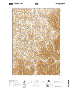
2019 Map of Russian Mission C-2 NW
USGS Topo · Published 2019About this map
Wetlands and low-lying drainages dominate the landscape within the T19n R58w and T19n R57w townships in this remote section of the Bethel Census Area. The terrain transitions from an intricate network of small ponds and marshes in the west to more pronounced topographical elevations in the east, particularly within T18n R57w. This 2019 survey reflects a wilderness largely devoid of named settlements or infrastructure, highlighting the complex natural hydrography that defines the Yukon-Kuskokwim Delta region. Researchers can trace the fine-grained contour intervals that delineate subtle rises between the saturated basins of T18n R58w and the higher ground toward the eastern quadrangle boundary.
Find a feature on this map
4 named features on this map. Tap any name to fly to it.
Don’t see what you’re looking for? This feature index may not catch every label — zoom into the map to look around manually.
Map Details
Editions of this 2019 Russian Mission C-2 NW Map
This is the sole edition of this map. No revisions or reprints were ever made.
Other maps of this area

1947 · Russian Mission
USGS Topo · 1:250,000

1950 · Russian Mission
USGS Topo · 1:250,000

1952 · Russian Mission D-2
USGS Topo · 1:63,360

1952 · Russian Mission D-3
USGS Topo · 1:63,360

1952 · Russian Mission C-3
USGS Topo · 1:63,360

1952 · Russian Mission C-2
USGS Topo · 1:63,360

1980 · Russian Mission
USGS Topo · 1:250,000
2019 · Russian Mission C-2 SE
USGS Topo · 1:25,000
2019 · Russian Mission D-2 SE
USGS Topo · 1:25,000
2019 · Russian Mission C-3 NE
USGS Topo · 1:25,000