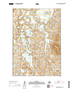
2019 Map of Russian Mission D-2 NE
USGS Topo · Published 2019About this map
The jurisdictional boundary between the Yukon-Koyukuk Census Area Bethel Census Area bisects this remote Alaskan landscape. This 2019 survey documents a complex network of meandering waterways and lake systems within the Unorganized Borough, primarily defined by the Public Land Survey System grids of T22n R56w, T22n R55w, T21n R56w, and T21n R55w. The absence of named settlements or roads highlights the wilderness character of the region, where the terrain is shaped by hydraulic processes rather than human development. While modern in its data sources, including National Hydrography Dataset layers, the map provides a foundational view of a landscape where administrative lines on a map are the only indicators of human structure.
Find a feature on this map
5 named features on this map. Tap any name to fly to it.
Don’t see what you’re looking for? This feature index may not catch every label — zoom into the map to look around manually.
Map Details
Editions of this 2019 Russian Mission D-2 NE Map
This is the sole edition of this map. No revisions or reprints were ever made.
Other maps of this area

1947 · Russian Mission
USGS Topo · 1:250,000

1950 · Russian Mission
USGS Topo · 1:250,000

1951 · Holy Cross
USGS Topo · 1:250,000

1952 · Holy Cross A-2
USGS Topo · 1:63,360

1952 · Holy Cross A-1
USGS Topo · 1:63,360

1952 · Russian Mission D-2
USGS Topo · 1:63,360

1952 · Holy Cross
USGS Topo · 1:250,000

1952 · Russian Mission D-1
USGS Topo · 1:63,360

1980 · Russian Mission
USGS Topo · 1:250,000
2019 · Russian Mission D-2 SE
USGS Topo · 1:25,000