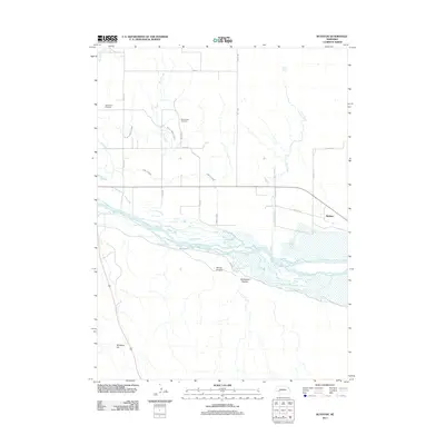
2011 Map of Ruthton
USGS Topo · Published 2011About this map
The North Platte River defines the southern portion of this landscape, its braided channels carving a wide path through Keith County. To the north, the small settlement of Ruthton sits near the eastern edge, supported by an intricate network of water management features including the Blue Creek Canal and the Graf Canal. These man-made waterways emphasize the region's reliance on irrigation for agriculture in the early 21st century. High ground is marked by prominent landmarks such as Windlass Hill and the rugged cuts of Spring Canyon and Dankworth Canyon. Local genealogy and settlement history are anchored by the Ash Creek Cemetery and Plum Creek Cemetery, which serve as quiet markers of the community's past along the namesake Ash Creek and Plum Creek drainages.
Find a feature on this map
24 named features on this map. Tap any name to fly to it.
Don’t see what you’re looking for? This feature index may not catch every label — zoom into the map to look around manually.
Map Details
Editions of this 2011 Ruthton Map
This is the sole edition of this map. No revisions or reprints were ever made.
Other maps of this area

1897 · Ogallala
USGS Topo · 1:125,000

1900 · Chappell
USGS Topo · 1:125,000

1900 · Ogallala
USGS Topo · 1:125,000

1954 · Scottsbluff
USGS Topo · 1:250,000

1954 · North Platte
USGS Topo · 1:250,000

1956 · North Platte
USGS Topo · 1:250,000

1957 · North Platte
USGS Topo · 1:250,000

1958 · Scottsbluff
USGS Topo · 1:250,000

1967 · North Platte
USGS Topo · 1:250,000
1971 · Brule NW
USGS Topo · 1:24,000