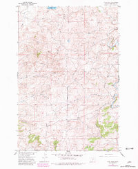
1954 Map of Ryan Creek
USGS Topo · Published 1981About this map
Sweet Grass Creek flows through a landscape defined by ranching and an intricate drainage network in the mid-1950s. The presence of Wulff Ranch in the northeast corner serves as a primary marker of human settlement in this section of Sweet Grass County. Topography is characterized by high ridges and deep ravines, including Nash Gulch and Tangen Draw, which channel seasonal water toward the primary creeks. In the north, Glasston Lake provides a rare stationary water feature on the high plains.
Find a feature on this map
15 named features on this map. Tap any name to fly to it.
Don’t see what you’re looking for? This feature index may not catch every label — zoom into the map to look around manually.
Map Details
Editions of this 1954 Ryan Creek Map
2 editions found
Other maps of this area

1889 · Big Snowy Mountain
USGS Topo · 1:250,000

1891 · Big Timber
USGS Topo · 1:125,000

1893 · Big Snowy Mountain
USGS Topo · 1:250,000

1893 · Big Timber
USGS Topo · 1:125,000

1954 · Big Timber
USGS Topo · 1:24,000
1954 · Otter Creek School
USGS Topo · 1:24,000
1954 · Ryan Creek
USGS Topo · 1:24,000

1954 · Billings
USGS Topo · 1:250,000

1954 · Roundup
USGS Topo · 1:250,000

1955 · Greycliff
USGS Topo · 1:24,000