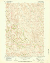
1970 Map of S R Springs
USGS Topo · Published 1973About this map
S R Springs and the surrounding drainage basins of Sheridan County are documented here as they appeared during the early 1970s. This survey, based on 1969 aerial photography, highlights a landscape defined by an intricate network of seasonal waterways and named draws. The branching systems of Badger Creek, including its Middle Fork and South Fork, dominate the northern half of the sheet. To the south, the topography is shaped by Arkansas Creek and Buffalo Creek, reflecting the importance of water sources in this arid ranching country.
Find a feature on this map
20 named features on this map. Tap any name to fly to it.
Don’t see what you’re looking for? This feature index may not catch every label — zoom into the map to look around manually.
Map Details
Editions of this 1970 S R Springs Map
This is the sole edition of this map. No revisions or reprints were ever made.
Other maps of this area

1909 · Sheridan
USGS Topo · 1:125,000

1911 · Sheridan
USGS Topo · 1:125,000

1955 · Sheridan
USGS Topo · 1:250,000

1958 · Sheridan
USGS Topo · 1:250,000

1962 · Sheridan
USGS Topo · 1:250,000
1970 · O T O Ranch
USGS Topo · 1:24,000
1970 · Verona
USGS Topo · 1:24,000
1970 · Ulm
USGS Topo · 1:24,000
1970 · Cedar Canyon
USGS Topo · 1:24,000
1970 · Jones Draw
USGS Topo · 1:24,000