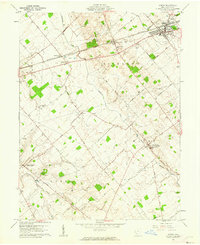
1961 Map of Sabina
USGS Topo · Published 1962About this map
The Baltimore and Ohio and Pennsylvania railroads intersect at Sabina, a central hub in Clinton County where agricultural production met the transit lines. This 1961 survey illustrates the rural landscape of the Virginia Military District, characterized by dispersed farmsteads and small crossroads settlements like Reesville, Melvin, and New Antioch. The southern portion of the quadrangle shows Centerville (Lees Creek PO), while the surrounding countryside is dotted with local landmarks of genealogical value, such as the Richland Ch and the Simon Kenton Sch. Drainage follows the natural contours of Anderson Fork and Wilson Creek, with small industrial sites like a Quarry and Gravel Pit highlighting the local extraction activities that supported regional road development. The map also meticulously preserves the locations of several family burial grounds, including Spurgeon Cem and Garrard Cem.
Find a feature on this map
60 named features on this map. Tap any name to fly to it.
Don’t see what you’re looking for? This feature index may not catch every label — zoom into the map to look around manually.
Map Details
Editions of this 1961 Sabina Map
2 editions found
Other maps of this area

1907 · Blanchester
USGS Topo · 1:62,500

1916 · Octa
USGS Topo · 1:62,500

1917 · Xenia
USGS Topo · 1:62,500

1917 · Sabina
USGS Topo · 1:62,500

1943 · Sabina
USGS Topo · 1:62,500

1944 · Octa
USGS Topo · 1:62,500

1947 · Columbus
USGS Topo · 1:250,000

1955 · Port William
USGS Topo · 1:24,000

1960 · Martinsville
USGS Topo · 1:24,000
1960 · Leesburg
USGS Topo · 1:24,000