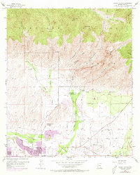
1957 Map of Sabino Canyon
USGS Topo · Published 1973About this map
Coronado National Forest dominates the upper half of this landscape, where the Santa Catalina foothills meet the desert floor. The 1957 terrain is defined by dramatic drainage systems like Sabino Canyon and Ventana Canyon, which channel water toward the developing valley below. In the lower sections of the map, urban expansion is captured through purple-tinted updates from 1971, showing the residential growth pushing toward Tanque Verde Road and Ft Lowell Road.
Find a feature on this map
42 named features on this map. Tap any name to fly to it.
Don’t see what you’re looking for? This feature index may not catch every label — zoom into the map to look around manually.
Map Details
Editions of this 1957 Sabino Canyon Map
5 editions found
Other maps of this area

1904 · Tucson
USGS Topo · 1:125,000

1905 · Tucson
USGS Topo · 1:125,000

1948 · Tucson
USGS Topo · 1:62,500

1956 · Tucson
USGS Topo · 1:250,000

1957 · Tucson East
USGS Topo · 1:24,000

1957 · Bellota Ranch
USGS Topo · 1:62,500

1957 · Tucson
USGS Topo · 1:24,000

1957 · Tucson
USGS Topo · 1:62,500

1957 · Rincon Valley
USGS Topo · 1:62,500

1957 · Sabino Canyon
USGS Topo · 1:24,000