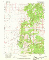
1959 Map of Sacramento Pass
USGS Topo · Published 1970About this map
Osceola (Site) and Black Horse (Site) stand as quiet reminders of Nevada's mining past, appearing here only as named locations rather than active settlements. Located within the high-altitude landscape of the Humboldt National Forest, the map details a region defined by its rugged peaks, including Windy Peak and Bald Mtn, and the critical passage of Sacramento Pass. The transition from the broad, flat Spring Valley to the Snake Range is marked by numerous water sources such as South Bastian Spring and Willard Springs, which were essential for the small mining outposts and ranching operations like Hogum. This 1959 survey records a landscape of resource extraction, noting the Crystal Queen Mine and a Burnt Mill, while also identifying family-related features like Graves near the former site of Black Horse. The presence of Stella Lake and Blue Lake in the southern high country highlights the varied hydrology of the range.
Find a feature on this map
64 named features on this map. Tap any name to fly to it.
Don’t see what you’re looking for? This feature index may not catch every label — zoom into the map to look around manually.
Map Details
Editions of this 1959 Sacramento Pass Map
3 editions found
Other maps of this area

1948 · Wheeler Peak
USGS Topo · 1:62,500

1949 · Garrison
USGS Topo · 1:62,500

1950 · Wheeler Peak
USGS Topo · 1:62,500

1951 · Garrison
USGS Topo · 1:62,500

1952 · Ely
USGS Topo · 1:125,000

1956 · Lund
USGS Topo · 1:250,000

1956 · Ely
USGS Topo · 1:250,000

1959 · Ely
USGS Topo · 1:250,000

1959 · Sacramento Pass
USGS Topo · 1:62,500

1959 · Connors Pass
USGS Topo · 1:62,500