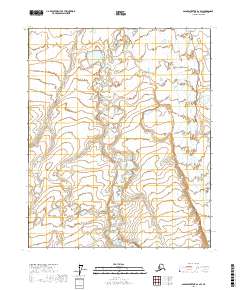
2017 Map of Sagavanirktok D-1 SW
USGS Topo · Published 2017About this map
Kavik River meanders through the eastern portion of this Arctic landscape, defining the primary drainage for the area. The terrain is characterized by a complex network of wetlands and small water bodies typical of the North Slope, documented during this 2017 study by the U.S. Geological Survey. The map provides specific boundary information for townships including T6n R18e and T5n R19e, which are essential for identifying specific land tracts in this expansive environment. While the area lacks developed settlements or road infrastructure, the intricate hydrography shows a delicate tundra ecosystem defined by seasonal water flow and saturated soils.
Find a feature on this map
5 named features on this map. Tap any name to fly to it.
Don’t see what you’re looking for? This feature index may not catch every label — zoom into the map to look around manually.
Map Details
Editions of this 2017 Sagavanirktok D-1 SW Map
This is the sole edition of this map. No revisions or reprints were ever made.
Other maps of this area

1951 · Sagavanirktok D-5
USGS Topo · 1:250,000
1955 · Sagavanirktok D-2
USGS Topo · 1:63,360
1955 · Sagavanirktok C-1
USGS Topo · 1:63,360
1955 · Sagavanirktok D-1
USGS Topo · 1:63,360

1956 · Sagavanirktok
USGS Topo · 1:250,000

1958 · Sagavanirktok
USGS Topo · 1:250,000

1964 · Sagavanirktok
USGS Topo · 1:250,000
1971 · Sagavanirktok C-2
USGS Topo · 1:63,360
2017 · Sagavanirktok D-1 NW
USGS Topo · 1:25,000
2017 · Sagavanirktok D-1 NE
USGS Topo · 1:25,000