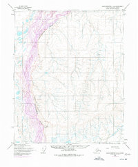
1955 Map of Sagavanirktok D-3
USGS Topo · Published 1977About this map
Sagavanirktok River dominates this Arctic landscape, its braided channels and vast gravel bars winding through the North Slope. Originally mapped in 1955 and updated with 1975 aerial photography, the sheet documents a specific moment of transition in the Alaskan wilderness before extensive infrastructure developments. To the east of the river, the Franklin Bluffs rise as a prominent topographical landmark, providing a stark vertical contrast to the surrounding tundra. This survey also records isolated points of interest such as Greta and Bruce, which serve as critical markers for navigation or research in an area largely devoid of permanent settlements or roads. The terrain is characterized by intricate drainage patterns and small lakes that hint at the complex permafrost hydrology typical of this high-latitude region.
Find a feature on this map
4 named features on this map. Tap any name to fly to it.
Don’t see what you’re looking for? This feature index may not catch every label — zoom into the map to look around manually.
Map Details
Editions of this 1955 Sagavanirktok D-3 Map
2 editions found
Other maps of this area

1951 · Beechey Point
USGS Topo · 1:250,000

1951 · Sagavanirktok D-5
USGS Topo · 1:250,000

1955 · Beechey Point
USGS Topo · 1:250,000

1955 · Beechey Point A-2
USGS Topo · 1:63,360

1955 · Beechey Point A-3
USGS Topo · 1:63,360

1955 · Beechey Point A-4
USGS Topo · 1:63,360

1955 · Sagavanirktok D-3
USGS Topo · 1:63,360
1955 · Sagavanirktok D-2
USGS Topo · 1:63,360

1955 · Sagavanirktok D-4
USGS Topo · 1:63,360

1956 · Sagavanirktok
USGS Topo · 1:250,000