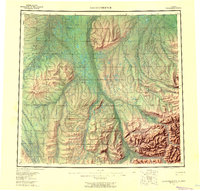
1956 Map of Sagavanirktok
USGS Topo · Published 1961About this map
The Sagavanirktok River and its vast network of tributaries dominate this mid-century portrait of the Alaskan North Slope. In an era before the discovery of massive oil reserves transformed the region, the landscape was defined by remote outposts like Franklin Bluffs and the presence of ephemeral transport routes. The transition from the coastal plain to more complex terrain is visible in the White Hills and the rising elevations toward the south. Movement across this roadless expanse relied on a Tractor Trail and a Winter Trail, providing essential links between the river drainage systems. These pathways followed the natural contours of the land, connecting the Toolik River and Ivishak River watersheds. The map also records early geographic nomenclature for features like Cache One Lake and Gilead Creek, which were key reference points for researchers and early surveyors in the Brooks Range foothills.
Find a feature on this map
23 named features on this map. Tap any name to fly to it.
Don’t see what you’re looking for? This feature index may not catch every label — zoom into the map to look around manually.
Map Details
Editions of this 1956 Sagavanirktok Map
5 editions found

Other maps of this area

1951 · Harrison Bay
USGS Topo · 1:250,000

1951 · Beechey Point
USGS Topo · 1:250,000

1951 · Sagavanirktok D-5
USGS Topo · 1:250,000

1951 · Chandler Lake
USGS Topo · 1:250,000

1951 · Brooks
USGS Topo · 1:250,000

1951 · Arctic
USGS Topo · 1:250,000

1951 · Mt. Michelson
USGS Topo · 1:250,000

1952 · Umiat
USGS Topo · 1:250,000

1955 · Flaxman Island
USGS Topo · 1:250,000

1955 · Harrison Bay
USGS Topo · 1:250,000