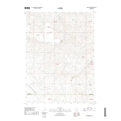
2017 Map of Sagebrush Park
USGS Topo · Published 2017About this map
Whiskey Peak and the surrounding high country of Green Mtn define this landscape along the border of Fremont and Sweetwater Counties. This 2017 survey details a network of high-altitude drainages, including Crooks Creek and Lost Soldier Creek, which carve through the varied terrain of Rocky Canyon and Stratton Hollow. The map provides a contemporary record of the Continental Divide National Scenic Trail, which traverses the southwestern section of the quadrangle. For those interested in the hydrology and geography of the region, the document shows several open parklands like Sagebrush Park and Round Park, along with distinct topographical features such as Whiskey Ridge and Stratton Rim. The primary access is via Green Mountain Rd, which winds through the northwestern slopes.
Find a feature on this map
33 named features on this map. Tap any name to fly to it.
Don’t see what you’re looking for? This feature index may not catch every label — zoom into the map to look around manually.
Map Details
Editions of this 2017 Sagebrush Park Map
This is the sole edition of this map. No revisions or reprints were ever made.
Other maps of this area

1951 · Crooks Creek NE
USGS Topo · 1:24,000

1951 · Split Rock
USGS Topo · 1:24,000

1951 · Split Rock NW
USGS Topo · 1:24,000

1955 · Casper
USGS Topo · 1:250,000

1957 · Jeffrey City
USGS Topo · 1:24,000

1958 · Casper
USGS Topo · 1:250,000
1961 · Osborne Well
USGS Topo · 1:24,000

1961 · Hadsell Spring
USGS Topo · 1:24,000

1961 · Crooks Peak
USGS Topo · 1:24,000

1961 · Bairoil
USGS Topo · 1:24,000