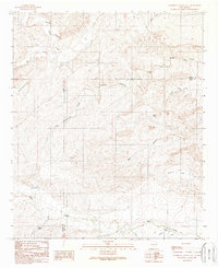
1989 Map of Sagebrush Valley East
USGS Topo · Published 1989About this map
Sagebrush Valley dominates this landscape along the border of Chaves and Eddy Counties, characterized by a complex network of ephemeral drainage draws and remote water management. The northern reach is defined by the Rio Felix, while the southern portion features the winding course of Eagle Creek. This 1980s-era data highlights a landscape primarily utilized for ranching and resource management, as evidenced by a series of named water tanks and wells including Dutch Tank, Young Tank, and the historic CCC Tank. The intricate topography of the Pecos Valley watershed is visible through the numerous named canyons like Squaw Canyon and Well Canyon that carve through the high plains. The lack of major paved roads underscores the isolation of these drainage systems, such as North Cottonwood Creek and Goaty Canyon Creek, in a region where water sources remain the most critical landmarks.
Find a feature on this map
22 named features on this map. Tap any name to fly to it.
Don’t see what you’re looking for? This feature index may not catch every label — zoom into the map to look around manually.
Map Details
Editions of this 1989 Sagebrush Valley East Map
This is the sole edition of this map. No revisions or reprints were ever made.
Other maps of this area

1954 · Carlsbad
USGS Topo · 1:250,000

1955 · Hope NW
USGS Topo · 1:24,000

1955 · Kincaid Ranch
USGS Topo · 1:24,000

1955 · Hope
USGS Topo · 1:24,000

1955 · Roswell
USGS Topo · 1:250,000

1956 · Hope
USGS Topo · 1:24,000

1958 · Carlsbad
USGS Topo · 1:250,000

1958 · Roswell
USGS Topo · 1:250,000

1960 · Teel Ranch
USGS Topo · 1:62,500

1961 · Indian Bluff
USGS Topo · 1:62,500