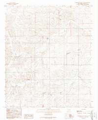
1989 Map of Sagebrush Valley West
USGS Topo · Published 1989About this map
Rio Felix and Eagle Creek wind through the arid expanse of the Sagebrush Valley in Chaves County, defining a landscape shaped by intermittent water and ranching infrastructure. This 1989 survey captures a network of essential landmarks for livestock management, including the North Windmill, Teclote Windmill, and Cottonwood Windmill, which served as critical water sources in this high desert environment. The presence of a remote Landing Strip near the northern banks of the Rio Felix suggests the importance of aerial access for managing large, isolated land holdings. In the southern portion of the quadrangle, the terrain transitions into the seasonal drainage of Singer Lake Draw, illustrating the ephemeral nature of local waterways and the specialized infrastructure, such as the Metal Tank, required to sustain life in this part of New Mexico.
Find a feature on this map
14 named features on this map. Tap any name to fly to it.
Don’t see what you’re looking for? This feature index may not catch every label — zoom into the map to look around manually.
Map Details
Editions of this 1989 Sagebrush Valley West Map
This is the sole edition of this map. No revisions or reprints were ever made.
Other maps of this area

1954 · Carlsbad
USGS Topo · 1:250,000

1955 · Roswell
USGS Topo · 1:250,000

1958 · Carlsbad
USGS Topo · 1:250,000

1958 · Roswell
USGS Topo · 1:250,000

1960 · Teel Ranch
USGS Topo · 1:62,500

1961 · Flying H
USGS Topo · 1:62,500

1961 · Indian Bluff
USGS Topo · 1:62,500

1962 · Roswell
USGS Topo · 1:250,000

1962 · Dunken
USGS Topo · 1:62,500

1978 · Artesia
USGS Topo · 1:100,000