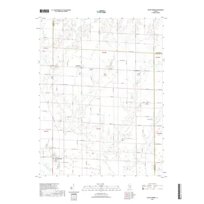
2018 Map of Sailor Springs
USGS Topo · Published 2018About this map
Sailor Springs anchors the southwestern corner of this Illinois landscape, situated at the edge of the Little Muddy Cr drainage. This 2018 edition reveals a deeply agricultural region defined by a grid of rural routes like Co HWY 7 and Ingraham Ln, connecting the small communities of Ingraham and Wendelin. Genealogists will find a wealth of burial sites dotting the countryside, including Wendelin-Holy Cross Cem, Saint Johns Cem, and McKinney Cem. The terrain is marked by subtle rises such as Turkey Point and Indian Point, which overlook the winding paths of Big Muddy Cr and its various tributaries like Weather Cr and Wolf Cr. The intersection of Clay, Jasper, and Richland counties creates a complex network of boundary lines that have influenced local land ownership and development for generations.
Find a feature on this map
89 named features on this map. Tap any name to fly to it.
Don’t see what you’re looking for? This feature index may not catch every label — zoom into the map to look around manually.
Map Details
Editions of this 2018 Sailor Springs Map
This is the sole edition of this map. No revisions or reprints were ever made.
Other maps of this area

1941 · Newton
USGS Topo · 1:62,500

1943 · Newton
USGS Topo · 1:62,500

1948 · Flora
USGS Topo · 1:62,500

1949 · Olney
USGS Topo · 1:62,500

1949 · Flora
USGS Topo · 1:62,500

1953 · Sailor Springs
USGS Topo · 1:62,500

1958 · Belleville
USGS Topo · 1:250,000

1962 · Belleville
USGS Topo · 1:250,000

1970 · Clay City
USGS Topo · 1:24,000
1970 · Flora
USGS Topo · 1:24,000