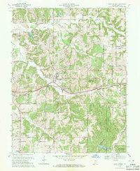
1969 Map of Saint Anthony
USGS Topo · Published 1971About this map
Saint Anthony and Schnellville anchor this southern Indiana landscape, which was updated in the late 1960s to reflect the era's evolving terrain. The northern reaches are defined by the drainage patterns of Hall Creek and the Grassy Fork, while the southern portion is heavily influenced by the expansion of the Ferdinand State Forest. The map documents a rural society built around local institutions, including the Sacred Heart Sch and several family or community burial grounds like Dugan Cem and Cox Cem.
Find a feature on this map
28 named features on this map. Tap any name to fly to it.
Don’t see what you’re looking for? This feature index may not catch every label — zoom into the map to look around manually.
Map Details
Editions of this 1969 Saint Anthony Map
2 editions found
Other maps of this area

1900 · St Meinrad
USGS Topo · 1:62,500

1903 · St. Meinrad
USGS Topo · 1:62,500

1946 · Jasper
USGS Topo · 1:24,000

1954 · Dubois
USGS Topo · 1:24,000

1954 · Huntingburg
USGS Topo · 1:24,000

1955 · Saint Anthony
USGS Topo · 1:24,000

1956 · Vincennes
USGS Topo · 1:250,000

1957 · Vincennes
USGS Topo · 1:250,000

1957 · Cuzco
USGS Topo · 1:24,000

1957 · Birdseye
USGS Topo · 1:24,000