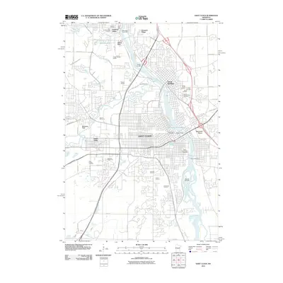
2010 Map of Saint Cloud
USGS Topo · Published 2010About this map
Saint Cloud and Sauk Rapids are shown at a peak of modern expansion along the banks of the Mississippi River. The landscape is dominated by the river's influence, from the industrial corridors near the Saint Cloud Dam to the educational hub of Saint Cloud State University. The density of cemeteries, including Saint Francis Xavier Cemetery and North Star Cemetery, provides a rich resource for genealogists tracing local lineage.
Find a feature on this map
76 named features on this map. Tap any name to fly to it.
Don’t see what you’re looking for? This feature index may not catch every label — zoom into the map to look around manually.
Map Details
Editions of this 2010 Saint Cloud Map
This is the sole edition of this map. No revisions or reprints were ever made.
Other maps of this area

1950 · St. Cloud
USGS Topo · 1:62,500

1951 · Annandale
USGS Topo · 1:62,500

1953 · Saint Cloud
USGS Topo · 1:250,000

1957 · Saint Cloud
USGS Topo · 1:250,000

1958 · Saint Cloud
USGS Topo · 1:250,000

1965 · St Stephen
USGS Topo · 1:24,000

1965 · St Joseph
USGS Topo · 1:24,000

1967 · Rockville
USGS Topo · 1:24,000
1974 · Cable
USGS Topo · 1:24,000
1974 · St Augusta
USGS Topo · 1:24,000