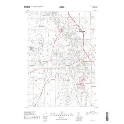
2019 Map of Saint Cloud
USGS Topo · Published 2019About this map
The Mississippi River serves as the central artery for this late-2010s look at Central Minnesota, where the cities of St. Cloud, Sauk Rapids, Sartell, and Waite Park converge. The landscape is defined by its educational and religious institutions, featuring the campus of Saint Cloud State University and the Saint Cloud Technical College. Local history and genealogy are well-represented by numerous burial grounds, including the Pioneer Benton County Cemetery and Calvary Cemetery, alongside established congregations such as Assumption Church.
Find a feature on this map
57 named features on this map. Tap any name to fly to it.
Don’t see what you’re looking for? This feature index may not catch every label — zoom into the map to look around manually.
Map Details
Editions of this 2019 Saint Cloud Map
This is the sole edition of this map. No revisions or reprints were ever made.
Other maps of this area

1950 · St. Cloud
USGS Topo · 1:62,500

1951 · Annandale
USGS Topo · 1:62,500

1953 · Saint Cloud
USGS Topo · 1:250,000

1957 · Saint Cloud
USGS Topo · 1:250,000

1958 · Saint Cloud
USGS Topo · 1:250,000

1965 · St Stephen
USGS Topo · 1:24,000

1965 · St Joseph
USGS Topo · 1:24,000

1967 · Rockville
USGS Topo · 1:24,000
1974 · Cable
USGS Topo · 1:24,000
1974 · St Augusta
USGS Topo · 1:24,000