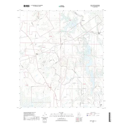
2018 Map of Saint Landry
USGS Topo · Published 2018About this map
Chicot State Park dominates the eastern half of this Louisiana landscape, where the waters of Lake Chicot and Mountain Bayou Lake wind through the wetlands of Evangeline Parish. The map reveals a high density of small, family-named burial sites such as Chaney Cem, Clark Cem, and Murdock Cem, suggesting a long history of rural homesteading and generational land ownership in the vicinity of Bayou Chicot.
Find a feature on this map
74 named features on this map. Tap any name to fly to it.
Don’t see what you’re looking for? This feature index may not catch every label — zoom into the map to look around manually.
Map Details
Editions of this 2018 Saint Landry Map
This is the sole edition of this map. No revisions or reprints were ever made.
Other maps of this area

1935 · Turkey Creek
USGS Topo · 1:62,500

1939 · Opelousas
USGS Topo · 1:62,500

1947 · Ville Platte
USGS Topo · 1:31,680

1948 · Bunkie
USGS Topo · 1:62,500

1949 · Turkey Creek
USGS Topo · 1:62,500

1952 · Lake Charles
USGS Topo · 1:250,000

1954 · Lake Charles
USGS Topo · 1:250,000

1956 · Opelousas
USGS Topo · 1:62,500

1957 · Opelousas
USGS Topo · 1:62,500
1960 · Ville Platte
USGS Topo · 1:62,500