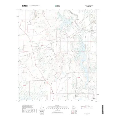
2020 Map of Saint Landry
USGS Topo · Published 2020About this map
Lake Chicot and its extensive Chicot Lake Trail system dominate the eastern half of this Evangeline Parish landscape, where the waters of Bayou Cocodrie and Mountain Bayou Lake converge. The topography is defined by the transition from bottomlands like Deep Slough to the slightly elevated terrain of Cedar Ridge. This 2020 record captures a region deeply rooted in local history, evidenced by the numerous family and community burial grounds scattered throughout, including Chaney Cem, Vandenburg Cem, and the Saint Theresa Mission Cem near the settlement of Saint Landry. The road network, featuring routes such as Frontier Rd and Rte 115, connects small hubs like Bayou Chicot and Dossman to the surrounding forests and wetlands. Researchers can trace the drainage patterns of Coulee Manuel and Black Lake Bayou that have shaped the agricultural and social development of this rural Louisiana interior.
Find a feature on this map
69 named features on this map. Tap any name to fly to it.
Don’t see what you’re looking for? This feature index may not catch every label — zoom into the map to look around manually.
Map Details
Editions of this 2020 Saint Landry Map
This is the sole edition of this map. No revisions or reprints were ever made.
Other maps of this area

1935 · Turkey Creek
USGS Topo · 1:62,500

1939 · Opelousas
USGS Topo · 1:62,500

1947 · Ville Platte
USGS Topo · 1:31,680

1948 · Bunkie
USGS Topo · 1:62,500

1949 · Turkey Creek
USGS Topo · 1:62,500

1952 · Lake Charles
USGS Topo · 1:250,000

1954 · Lake Charles
USGS Topo · 1:250,000

1956 · Opelousas
USGS Topo · 1:62,500

1957 · Opelousas
USGS Topo · 1:62,500
1960 · Ville Platte
USGS Topo · 1:62,500