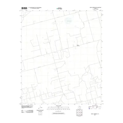
2010 Map of Saint Lawrence
USGS Topo · Published 2010About this map
Saint Lawrence serves as the focal point of this Glasscock County landscape, situated at the intersection of Farm Rd 2401 and Co Op Rd. The map illustrates a highly organized agricultural and ranching grid, where a network of county roads like Co Rd 150 and Paymaster Rd define the boundaries of large parcels. To the north, the presence of Blizzard Lake stands out as a significant local hydrologic feature amidst the surrounding plains. The local infrastructure is further marked by named thoroughfares such as Seidenberger and Angle Rd, reflecting the settlement patterns and road development that characterized this portion of West Texas in the early 21st century. The density of road names and rural junctions provides a clear view of the area's layout before more recent shifts in regional land use.
Find a feature on this map
15 named features on this map. Tap any name to fly to it.
Don’t see what you’re looking for? This feature index may not catch every label — zoom into the map to look around manually.
Map Details
Editions of this 2010 Saint Lawrence Map
This is the sole edition of this map. No revisions or reprints were ever made.
Other maps of this area

1954 · San Angelo
USGS Topo · 1:250,000

1958 · San Angelo
USGS Topo · 1:250,000

1963 · Garden City
USGS Topo · 1:24,000

1965 · San Angelo
USGS Topo · 1:250,000

1965 · Dewey Lake SE
USGS Topo · 1:24,000

1965 · Patterson Lake
USGS Topo · 1:24,000

1973 · Saint Lawrence SE
USGS Topo · 1:24,000

1973 · Bigby Corner
USGS Topo · 1:24,000
1973 · Slager Lake
USGS Topo · 1:24,000
1973 · Three Bluff Draw NW
USGS Topo · 1:24,000