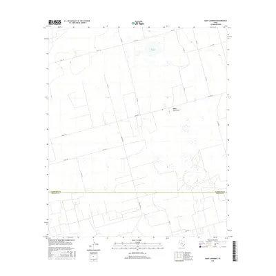
2016 Map of Saint Lawrence
USGS Topo · Published 2016About this map
Saint Lawrence serves as the focal point for this section of West Texas, situated along the county line where Glasscock Co meets its neighbor to the south. The landscape is characterized by a sparse, grid-like network of rural transit, anchored by Farm Rd 2401 and Ranch Rd 3093. A notable geographic feature in this arid environment is Blissard Lake, located in the northern portion of the quadrangle. The map captures an era of modern agricultural and utility infrastructure, indicated by the prominent Co-Op Rd and several other numeric county roads that support the local farming economy. The presence of Angle Rd at the southern boundary highlights the shift in survey patterns that often occurred along county or property divisions in this part of the state.
Find a feature on this map
17 named features on this map. Tap any name to fly to it.
Don’t see what you’re looking for? This feature index may not catch every label — zoom into the map to look around manually.
Map Details
Editions of this 2016 Saint Lawrence Map
This is the sole edition of this map. No revisions or reprints were ever made.
Other maps of this area

1954 · San Angelo
USGS Topo · 1:250,000

1958 · San Angelo
USGS Topo · 1:250,000

1963 · Garden City
USGS Topo · 1:24,000

1965 · San Angelo
USGS Topo · 1:250,000

1965 · Dewey Lake SE
USGS Topo · 1:24,000

1965 · Patterson Lake
USGS Topo · 1:24,000

1973 · Saint Lawrence SE
USGS Topo · 1:24,000

1973 · Bigby Corner
USGS Topo · 1:24,000
1973 · Slager Lake
USGS Topo · 1:24,000
1973 · Three Bluff Draw NW
USGS Topo · 1:24,000