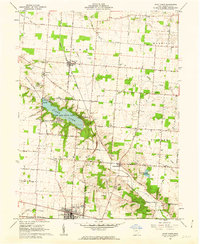
1961 Map of Saint Paris
USGS Topo · Published 1962About this map
Kiser Lake State Park dominates the central landscape of this Champaign County region, showing the developed recreational shoreline at Kiser Lake including Camp Shawano and the State Landing Strip. To the south, the village of Saint Paris serves as a local hub, featuring the Sewage Disposal plant and Harmon Memorial Park along the Pennsylvania Road. The surrounding rural townships are connected by the north-south route of the Detroit Toledo and Ironton RR, which passes through the grain and livestock country near Rosewood.
Find a feature on this map
69 named features on this map. Tap any name to fly to it.
Don’t see what you’re looking for? This feature index may not catch every label — zoom into the map to look around manually.
Map Details
Editions of this 1961 Saint Paris Map
2 editions found
Other maps of this area

1913 · Bellefontaine
USGS Topo · 1:48,000

1913 · Sidney
USGS Topo · 1:62,500

1914 · Troy
USGS Topo · 1:62,500

1914 · St. Paris
USGS Topo · 1:62,500

1915 · Bellefontaine
USGS Topo · 1:62,500

1916 · St. Paris
USGS Topo · 1:62,500

1944 · Sidney
USGS Topo · 1:62,500

1944 · St. Paris
USGS Topo · 1:62,500

1944 · Troy
USGS Topo · 1:62,500

1944 · Bellefontaine
USGS Topo · 1:62,500