
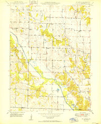
1950 Map of Saint Patrick
USGS Topo · Published 1950About this map
St Patrick and the rural community of Antioch center this 1950 topographical study of Northeast Missouri. The landscape is defined by the winding course of the Wyaconda River and its Old Channel, flanked by numerous small family and community burial grounds including Sisson Cem, Mitts Cem, and Cowgill Cem. The distribution of rural education is particularly well-documented here, showing local landmarks like Diamond Sch, Enterprise Sch, and the uniquely named Pride of the West Sch. Many of these country schools and churches, such as Cedar Grove Ch, served as the social anchors for the surrounding farmsteads before mid-century consolidation. The map also records early water management efforts, specifically the Levee systems along the Little Wyaconda River, illustrating the ongoing struggle to reclaim and protect the fertile bottomlands for agriculture.
Find a feature on this map
27 named features on this map. Tap any name to fly to it.
Don’t see what you’re looking for? This feature index may not catch every label — zoom into the map to look around manually.
Map Details
Editions of this 1950 Saint Patrick Map
2 editions found
Other maps of this area

1903 · Kahoka
USGS Topo · 1:125,000

1949 · Wayland
USGS Topo · 1:24,000

1949 · Kahoka SE
USGS Topo · 1:24,000

1949 · Kahoka
USGS Topo · 1:24,000

1949 · St. Patrick
USGS Topo · 1:24,000

1950 · Kahoka
USGS Topo · 1:24,000

1950 · Kahoka SE
USGS Topo · 1:24,000

1950 · Wayland
USGS Topo · 1:24,000

1950 · Neeper
USGS Topo · 1:24,000

1950 · Benjamin
USGS Topo · 1:24,000