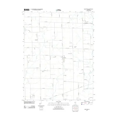
2012 Map of Saint Rose
USGS Topo · Published 2012About this map
Agricultural life in Clinton County is deeply etched into the landscape surrounding Saint Rose, where a dense network of family farms and dairy operations defines the local economy. The map reveals the persistence of legacy agriculture through named sites like the Blue Mound Dairy Farm, Timmermann Farms, and Tholeville Dairy. These holdings are situated amidst a drainage system of small creeks, including Spanker Br and Sugar Cr, which once dictated the placement of early settlements. For those researching local lineages, the map identifies several rural burial grounds such as Gullick Cem and Lake Branch Cem, alongside the small crossroads of Jamestown and Sebastopol. The inclusion of the Saint Rose Airport provides a modern navigational landmark within this traditional farming corridor, while the winding course of Shoal Cr marks the eastern boundary of the surveyed area.
Find a feature on this map
81 named features on this map. Tap any name to fly to it.
Don’t see what you’re looking for? This feature index may not catch every label — zoom into the map to look around manually.
Map Details
Editions of this 2012 Saint Rose Map
This is the sole edition of this map. No revisions or reprints were ever made.
Other maps of this area

1906 · Breese
USGS Topo · 1:62,500

1907 · Breese
USGS Topo · 1:62,500

1910 · Carlyle
USGS Topo · 1:62,500

1932 · Greenville
USGS Topo · 1:62,500

1937 · New Douglas
USGS Topo · 1:48,000

1939 · Greenville
USGS Topo · 1:62,500

1943 · Greenville
USGS Topo · 1:62,500

1944 · New Douglas
USGS Topo · 1:62,500

1948 · Carlyle
USGS Topo · 1:62,500
1957 · Highland
USGS Topo · 1:24,000