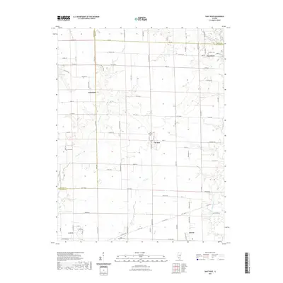
2021 Map of Saint Rose
USGS Topo · Published 2021About this map
St. Rose serves as a central hub in this agricultural landscape where the borders of Clinton, Madison, and Bond Counties meet. The terrain is defined by a network of drainage systems including Spanker Br, Lake Br, and Bull Br, which feed toward Shoal Creek in the east. These waterways historically dictated the placement of small rural communities and the gridded section lines of the Public Land Survey System. For genealogists, the map preserves the locations of community landmarks like Gullick Cem, Jamestown Cem, and Saint Rose Cem. The northern portion of the sheet reveals the small settlements of Jamestown and Sebastopol, while the southern edges reach the outskirts of Aviston and Breese. The intricate road system, from Bond Rd to Saint Rose Rd, illustrates the evolution of rural transport through this fertile portion of Southern Illinois.
Find a feature on this map
86 named features on this map. Tap any name to fly to it.
Don’t see what you’re looking for? This feature index may not catch every label — zoom into the map to look around manually.
Map Details
Editions of this 2021 Saint Rose Map
This is the sole edition of this map. No revisions or reprints were ever made.
Other maps of this area

1906 · Breese
USGS Topo · 1:62,500

1907 · Breese
USGS Topo · 1:62,500

1910 · Carlyle
USGS Topo · 1:62,500

1932 · Greenville
USGS Topo · 1:62,500

1937 · New Douglas
USGS Topo · 1:48,000

1939 · Greenville
USGS Topo · 1:62,500

1943 · Greenville
USGS Topo · 1:62,500

1944 · New Douglas
USGS Topo · 1:62,500

1948 · Carlyle
USGS Topo · 1:62,500
1957 · Highland
USGS Topo · 1:24,000