
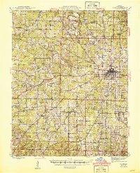
1945 Map of Salem
USGS Topo · Published 1945About this map
Salem serves as the focal point of this mid-century survey, shown as the terminus for the St. Louis-San Francisco RR during an era when rail and road systems were still closely tied to the region's topography. The landscape of Dent County is defined by its numerous small schoolhouses and churches, such as Oakland Sch and New Harmony Ch, reflecting a decentralized rural community structure. In the northeast, the Meramec River flows near Deep Ford, while the southern reaches feature the beginnings of Montauk State Park along the headwaters of the Current River. A high concentration of family cemeteries, including Karns Cem and Carty Cem, provides a detailed record of the families who settled these hills and hollows like Smoky Hollow and Montauk Hollow.
Find a feature on this map
88 named features on this map. Tap any name to fly to it.
Don’t see what you’re looking for? This feature index may not catch every label — zoom into the map to look around manually.
Map Details
Editions of this 1945 Salem Map
2 editions found
Other maps of this area

1912 · Rolla
USGS Topo · 1:62,500

1928 · Meramec Spring
USGS Topo · 1:62,500

1932 · Steelville
USGS Topo · 1:48,000

1932 · Cedar Grove
USGS Topo · 1:48,000

1933 · Steelville
USGS Topo · 1:62,500

1937 · Steelville
USGS Topo · 1:62,500

1937 · Edgar Springs
USGS Topo · 1:48,000

1941 · Salem
USGS Topo · 1:62,500

1941 · Stone Hill
USGS Topo · 1:62,500

1945 · Edgar Springs
USGS Topo · 1:62,500