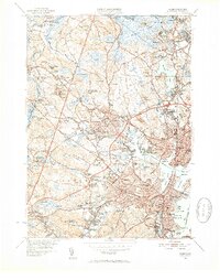
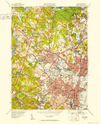
1949 Map of Salem
USGS Topo · Published 1952About this map
Salem and its surrounding North Shore communities appear here at the transition into the mid-century, defined by a dense network of industrial maritime heritage and sprawling institutional grounds. The coastline is punctuated by historic infrastructure like Derby Wharf and the Salem Terminal Wharf, while the interior reveals the extensive footprint of the Danvers State Hospital and the County Agricultural Sch at Hathorne. Genealogists will find a high density of burial sites, ranging from the historic Old Settlers Burying Ground to the Bradstreet & Porter Burying Ground. Transportation patterns are dominated by the Boston and Maine Railroad and the Newburyport Turnpike, which link the industrial centers of Peabody and Beverly with the agricultural lands of Wenham and Topsfield. This survey records the landscape before the massive post-war expansion of the suburbs, preserving the names of local corners like Burleys Corner and Tapleyville.
Find a feature on this map
141 named features on this map. Tap any name to fly to it.
Don’t see what you’re looking for? This feature index may not catch every label — zoom into the map to look around manually.
Map Details
Editions of this 1949 Salem Map
2 editions found
Other maps of this area

1886 · Lawrence
USGS Topo · 1:62,500

1888 · Lawrence
USGS Topo · 1:62,500

1888 · Salem
USGS Topo · 1:62,500

1892 · Boston Bay
USGS Topo · 1:62,500

1893 · Salem
USGS Topo · 1:62,500

1893 · Boston
USGS Topo · 1:62,500

1893 · Lawrence
USGS Topo · 1:62,500

1903 · Boston
USGS Topo · 1:62,500

1903 · Boston Bay
USGS Topo · 1:62,500

1917 · Salem
USGS Topo · 1:62,500