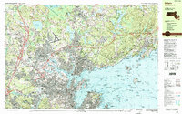
1985 Map of Salem
USGS Topo · Published 1986About this map
Salem Harbor and Marblehead Harbor anchor this coastal survey, which documents the North Shore's transition into the mid-1980s. The industrial and maritime legacy of the region is evident at Derby Wharf and the expansive United Shoe Machinery Corp complex in Beverly. Large institutional footprints such as the Danvers State Hospital and the Essex Agricultural and Technical Institute stand alongside historic defense sites like Fort Pickering and Fort Sewall.
Find a feature on this map
265 named features on this map. Tap any name to fly to it.
Don’t see what you’re looking for? This feature index may not catch every label — zoom into the map to look around manually.
Map Details
Editions of this 1985 Salem Map
3 editions found
Other maps of this area

1886 · Gloucester
USGS Topo · 1:62,500

1886 · Lawrence
USGS Topo · 1:62,500

1888 · Gloucester
USGS Topo · 1:62,500

1888 · Lawrence
USGS Topo · 1:62,500

1888 · Salem
USGS Topo · 1:62,500

1892 · Boston Bay
USGS Topo · 1:62,500

1893 · Salem
USGS Topo · 1:62,500

1893 · Boston
USGS Topo · 1:62,500

1893 · Lawrence
USGS Topo · 1:62,500

1893 · Gloucester
USGS Topo · 1:62,500