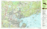
1985 Map of Salem
USGS Topo · Published 1986About this map
Salem and the surrounding North Shore communities of Beverly, Danvers, and Marblehead are captured during a period of late 20th-century density, showing a complex landscape where colonial history meets modern infrastructure. The map details the intricate coastline of Salem Sound, including Bakers Island and the military heritage sites at Fort Pickering and Fort Sewall. Significant institutional footprints are visible, from the Danvers State Hospital complex to Salem State College and the Bates Laboratory of Nuclear Science (MIT).
Find a feature on this map
109 named features on this map. Tap any name to fly to it.
Don’t see what you’re looking for? This feature index may not catch every label — zoom into the map to look around manually.
Map Details
Editions of this 1985 Salem Map
3 editions found
Other maps of this area

1886 · Gloucester
USGS Topo · 1:62,500

1886 · Lawrence
USGS Topo · 1:62,500

1888 · Gloucester
USGS Topo · 1:62,500

1888 · Lawrence
USGS Topo · 1:62,500

1888 · Salem
USGS Topo · 1:62,500

1892 · Boston Bay
USGS Topo · 1:62,500

1893 · Salem
USGS Topo · 1:62,500

1893 · Boston
USGS Topo · 1:62,500

1893 · Lawrence
USGS Topo · 1:62,500

1893 · Gloucester
USGS Topo · 1:62,500