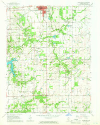
1965 Map of Salem South
USGS Topo · Published 1966About this map
Salem sits at a mid-century crossroads where the Baltimore and Ohio and Chicago and Eastern Illinois railroads intersect near the County Fairground. This portion of Marion County reveals a landscape transitioning from the municipal activity of the Sewage Disposal plant and Drive-in Theater to a rural network of small family-named landmarks. To the south, the waters of Lake Centralia and the meandering Crooked Creek define the topography, while the eastern reaches are marked by the small settlement of Cartter. The map records numerous country institutions, from the Raccoon Sch to several remote burial grounds like Antioch Cem and Dunkard Cem, which provide essential touchpoints for genealogical research. Scattered Oil Wells across the townships of Raccoon and Salem indicate the region's mid-century extractive industry, operating alongside established community centers like Young Chapel and Bethlehem Ch.
Find a feature on this map
45 named features on this map. Tap any name to fly to it.
Don’t see what you’re looking for? This feature index may not catch every label — zoom into the map to look around manually.
Map Details
Editions of this 1965 Salem South Map
2 editions found
Other maps of this area

1914 · Centralia
USGS Topo · 1:62,500

1933 · Mount Vernon
USGS Topo · 1:48,000

1934 · Salem
USGS Topo · 1:62,500

1935 · Centralia
USGS Topo · 1:62,500

1938 · Salem
USGS Topo · 1:62,500

1940 · Mount Vernon
USGS Topo · 1:62,500

1943 · Ashley
USGS Topo · 1:62,500

1946 · Ashley
USGS Topo · 1:62,500

1958 · Belleville
USGS Topo · 1:250,000

1962 · Belleville
USGS Topo · 1:250,000