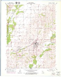
1956 Map of Salisbury
USGS Topo · Published 1979About this map
The town of Salisbury serves as the central hub of this Chariton County survey, anchored by the Wabash railroad line and a concentrated grid of streets and structures. Revisions from the late 1970s appear alongside 1950s data, showing the development of the Municipal Airfield and several Oil Tanks along the rail corridor. The landscape is defined by the complex hydrology of the Old Channel Chariton River and the Middle Fork Little Chariton River, which carve through the terrain south toward the Sterling Price Community Lake. Genealogists will find a high density of burial sites documented here, including Salisbury Cem, St Joseph Cem, and the remote Prairie Valley Cem to the north. Small settlements like Eccles and New Hope provide points of reference for tracing family roots across the townships of Wayland and Salisbury.
Find a feature on this map
27 named features on this map. Tap any name to fly to it.
Don’t see what you’re looking for? This feature index may not catch every label — zoom into the map to look around manually.
Map Details
Editions of this 1956 Salisbury Map
2 editions found
Other maps of this area

1890 · Glasgow
USGS Topo · 1:125,000

1953 · Moberly
USGS Topo · 1:250,000

1953 · Armstrong
USGS Topo · 1:24,000

1953 · Clifton Hill
USGS Topo · 1:24,000

1953 · Prairie Hill
USGS Topo · 1:24,000

1953 · Bynumville
USGS Topo · 1:24,000
1953 · Mike
USGS Topo · 1:24,000

1954 · Moberly
USGS Topo · 1:250,000
1956 · Salisbury
USGS Topo · 1:24,000
1956 · Keytesville
USGS Topo · 1:24,000