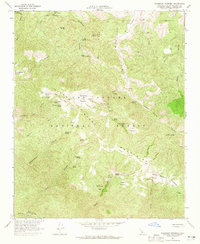
1964 Map of Salisbury Potrero
USGS Topo · Published 1965About this map
The Sierra Madre Mountains define this high-elevation landscape in the Los Padres National Forest, where a network of grazing flats or "potreros" are linked by the Sierra Madre Road and early pack trails. Salisbury Potrero and Santa Barbara Potrero represent key landmarks for local ranching and forest management history, supported by numerous named water sources such as Cherry Orchard Spring and Aguadulce Spring. In the southwest corner, the Sisquoc River flows near the Sisquoc Condor Sanctuary, a vital conservation zone established for the protection of the California condor. The prevalence of drill holes throughout Salisbury Canyon and across Bull Ridge indicates a period of active resource exploration in the mid-1960s, while family-named features like James Spring and Logan Potrero provide touchpoints for regional genealogy and history.
Find a feature on this map
50 named features on this map. Tap any name to fly to it.
Don’t see what you’re looking for? This feature index may not catch every label — zoom into the map to look around manually.
Map Details
Editions of this 1964 Salisbury Potrero Map
3 editions found
Other maps of this area

1902 · Santa Ynez
USGS Topo · 1:125,000

1905 · Santa Ynez
USGS Topo · 1:125,000

1941 · San Rafael Mtn.
USGS Topo · 1:62,500

1941 · McPherson Peak
USGS Topo · 1:62,500

1942 · San Rafael Mtn.
USGS Topo · 1:62,500

1942 · East of Cuyama Ranch
USGS Topo · 1:24,000

1943 · Big Pine Mountain
USGS Topo · 1:31,680

1943 · San Rafael Mtn.
USGS Topo · 1:62,500

1943 · McPherson Peak
USGS Topo · 1:62,500

1943 · Cuyama Ranch
USGS Topo · 1:31,680