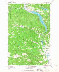
1965 Map of Salmon Lake
USGS Topo · Published 1968About this map
The Clearwater River corridor defines this mid-1960s landscape, serving as a vital hydrologic link between several glacial lakes. This survey documents the intersection of the Clearwater State Forest and the Lolo National Forest, revealing a region managed for both timber and recreation. Water features dominate the terrain, from the expansive Salmon Lake with its centrally located Sourdough Island to the smaller Harpers Lake and Blanchard Lake to the south. Cultural landmarks are sparse but significant, notably the St Joseph Ch and a dedicated Campground near the lake's eastern shore, reflecting the area's development for seasonal use. The topography is shaped by the Clearwater's meandering path and the surrounding heights of Boyd Mountain and Game Ridge, while the presence of a Gravel Pit indicates local resource extraction supporting the area's road network.
Find a feature on this map
23 named features on this map. Tap any name to fly to it.
Don’t see what you’re looking for? This feature index may not catch every label — zoom into the map to look around manually.
Map Details
Editions of this 1965 Salmon Lake Map
2 editions found
Other maps of this area

1902 · Ovando
USGS Topo · 1:125,000

1903 · Bonner
USGS Topo · 1:125,000

1905 · Ovando
USGS Topo · 1:125,000

1919 · Drummond
USGS Topo · 1:125,000

1921 · Drummond
USGS Topo · 1:125,000

1921 · Elbow Lake
USGS Topo · 1:125,000

1947 · Butte
USGS Topo · 1:250,000

1955 · Choteau
USGS Topo · 1:250,000

1957 · Choteau
USGS Topo · 1:250,000

1958 · Butte
USGS Topo · 1:250,000