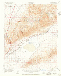
1943 Map of Saltdale
USGS Topo · Published 1956About this map
The arid landscape of the Mojave Desert is defined here by the vast expanse of Koehn Dry Lake, where commercial activity centered on the Salt Ponds near the settlement of Saltdale. The industrial character of the mid-1940s is evident in the network of mining operations scattered throughout the El Paso Mountains, including the Snowhite Mine and Bond Buyer Mine. These remote sites were connected to the wider region via the Southern Pacific railroad, which served small desert outposts like Garlock and Cantil.
Find a feature on this map
41 named features on this map. Tap any name to fly to it.
Don’t see what you’re looking for? This feature index may not catch every label — zoom into the map to look around manually.
Map Details
Editions of this 1943 Saltdale Map
4 editions found
Other maps of this area

1903 · Randsburg
USGS Topo · 1:62,500

1906 · Kernville
USGS Topo · 1:125,000

1908 · Kernville
USGS Topo · 1:125,000

1911 · Randsburg
USGS Topo · 1:62,500

1912 · Randsburg
USGS Topo · 1:62,500

1915 · Searles Lake
USGS Topo · 1:250,000

1915 · Mojave
USGS Topo · 1:125,000

1943 · Inyokern
USGS Topo · 1:62,500

1943 · Cross Mountain
USGS Topo · 1:62,500

1943 · Saltdale
USGS Topo · 1:62,500